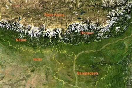
 The princely Kingdom of Bhutan is a landlocked country, about 350 km long and 150 km wide encompassing an area of 38,394 square kilometres. Located between longitude 88°45' and 92°10' East and latitudes 26°40' and 28°15' North in the Eastern Himalaya, it is bounded by India in South and South-West and Tibetan autonomous region of China in the North and North-West respectively. It shares a 470km border with Tibet (China’s Xizang Autonomous Region) in the north and northwest, 605km with the Indian state of Sikkim in the west, West Bengal in the southwest, Assam in the south and southeast, and Arunachal Pradesh in the east.
Virtually the entire country is mountainous, and ranges in elevation from 160m along the Indian border to the 7,570m Gangkhar Puensum on the Tibetan border. These two extremes frame a landscape that stretches from sub-tropical to arctic-like conditions. The maximum East-West stretch of the country is approximately 350km and north-South about 150km.
About 72 per cent of the Kingdom is covered with forests, 7 per cent with year-round snow and glaciers, nearly 3 per cent is cultivated or agriculture areas and 4 per cent as meadows and pastures. The rest of the land is either barren, rocky or scrubland.
Physiography
Talking in geomorphologic terms, Bhutan is distinctively divisible into three lateral zones from South to North. Incidentally, this zonation is more or less applicable to meteorological, ethnographical and geographical divisions of the country.
The Great Himalaya
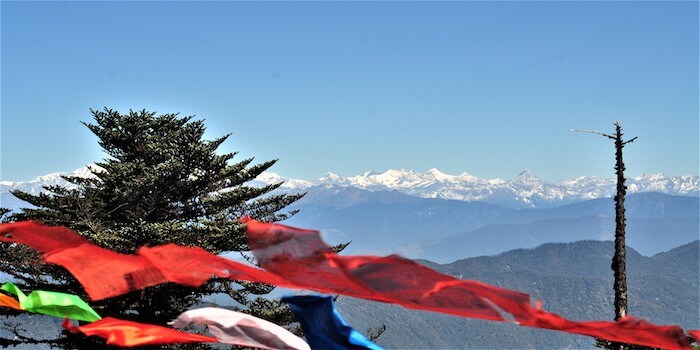
Extending from Mt. Chomolhari (7,314m) in the West to 7,570m Gangkhar Puensum near the Center point of the northern border between Tibet and Bhutan, this region is virtually a snow-wilderness zone where almost 20% of the land is under perpetual snow. This zone is represented by alpine meadows and the perpetually snowbound high summit of the Great Himalayan range.
The Inner Himalaya
This is the largest physiographic region of Bhutan and lies among broad valleys and forested hillsides from 1,100m to 3,000m in elevation. All the major towns of Bhutan are situated in this zone such as Paro, Thimphu, Punakha, in western Bhutan, Trongsa and Bumthang in central Bhutan and Mongar, Trashigang in eastern Bhutan.
The Southern foothills
Also called Himalayan foothills or Siwalik Hills, this zone occupies the southernmost part of the country. The plains in the south of the country are part of the region known as Terai, which extends from Kashmir, through Nepal, to Bhutan. The average annual rainfall in this region generally reaches up to 200 inches resulting to luxuriant vegetation particularly tropical forests rich in wildlife, while at times hot, steamy and unhealthy tracts are other features of this zone.
Drainage / River system
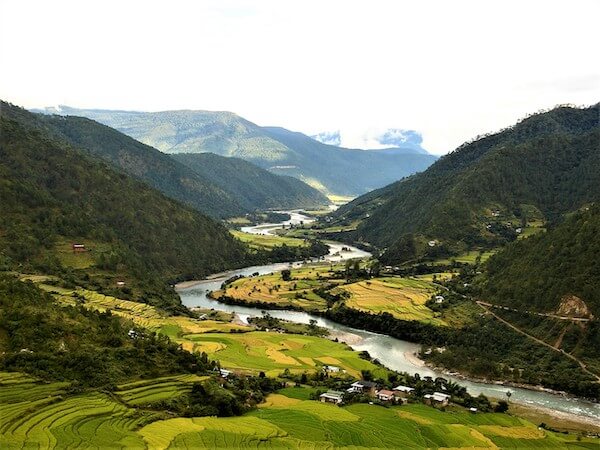
Rivers play an important role in Bhutan's physical, economic, social and cultural geography. Their enormous potential for hydroelectric power has helped in shaping the national economy. Since the central Himalayas of Bhutan receives the full brunt of the monsoon so the rivers are larger and have created much broader valleys than rivers further to the west in Nepal and India. In their upper reaches, most Bhutanese rivers have created large fertile valleys such as those of Paro, Punakha, Thimphu and Bumthang. As the rivers pass through the centre of Bhutan, the valleys become steeper and narrower, and roads have to climb high on the hillside.
Bhutan has four major river systems: the Drangmechhu; the Punatsangchhu; the Wangchhu; and the Amochhu. Each flow southerly through the Duars to join the Brahmaputra in India. The largest river system, the Drangmechhu, flows southwesterly from India’s state of Arunachal Pradesh and has three major tributaries: the Drangmechhu, Mangdechhu, and Chamkharchhu. These rivers form the Drangmechhu basin. In the Duars, where eight tributaries join, the Drangmechhu is called the Manaschhu. The 320km-long Punatsangchhu rises in northwestern Bhutan as the Mochhu and Phochhu, which are fed by the snows and glaciers from the Great Himalayan Range. They flow southerly to Punakha, where they join to form the Punatsangchhu, which flows southerly into India’s state of West Bengal. The Wangchhu, which is 370 kilometres, flows southeasterly through west-central Bhutan, drains the Haa, Paro, and Thimphu valleys, and continues through the foothills before it finally drains into West Bengal. The smallest river system, the Torsachhu, known as the Amo Chhu in its northern reaches, flows swiftly through western Bhutan before broadening near Phuentsholing and then flows into India. Glaciers in northern Bhutan, which cover about 10 per cent of the total surface area, are an important renewable source of water for Bhutan’s rivers.
 Meteorology and Vegetation
Bhutan's climate varies widely depending upon elevation and the country is divided into three distinct climatic zones: alpine, temperate and subtropical zones. The climate is humid and subtropical in the southern plains and foothills, temperate in the inner Himalayan valleys of the central regions, and cold in the north with year-round snow on the main Himalayan range. The eastern part of the country is warmer than the west. The central valleys of Punakha, Wangduephodrang, Mongar, Trashigang and Lhuntshi enjoy a semi-tropical climate with cool winters, whereas Paro, Thimphu, Trongsa and Bumthang have relatively harsher climates including snowfall in winter.
In the valleys where most tourist activities are concentrated, the winters (mid-November to mid-March) are dry with daytime temperatures of 12 – 14 degrees centigrade while evening and early morning are cold with nighttime temperature sometimes falling below zero.
Spring lasts from mid-March to the beginning of June, with temperatures warming gradually to 27-30 degrees centigrade by day and about 18 degrees centigrade at night. However, cold spells are possible up until the end of April, with a chance of new snow on the mountains above the valleys. Strong, gusty winds start blowing almost every day from noon to early evening. The first storms break, and they become more and more frequent with the approach of the monsoon which arrives in late June.
The country receives abundant rain especially in the south, as it gets the full face of monsoon coming from the Bay of Bengal. At the end of September first fortnight, after the last of the big rains, autumn suddenly arrives and the sky gets clear, a brisk breeze picks up and the temperature starts falling towards freezing at night although bright sunshine continues to keep the days warm. Autumn and Spring are the best times to visit this fascinating mountain Kingdom.
Annual precipitation ranges widely in various parts of the country. In the severe climate of the north, there is only about forty millimetres of annual precipitation—primarily snow. In the temperate central regions, a yearly average of around 1,000 millimetres is more common.
There is a pronounced difference in the vegetation cover in three different zones of the country, mostly due to the prevalence of varied climatic conditions across the Kingdom. The southern foothills are mostly covered with dense and thick deciduous trees while the inner regions are dotted with a large variety of plants, flowers and trees including birch, pine, chestnut, oak, apples, peaches and plums are also grown in the fertile valleys. The northern part with the tundra type of climate allows the growth of coniferous trees and other alpines growths like magnolia, rhododendrons, birch, fir, spruce, etc.